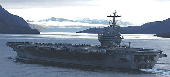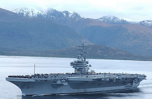
Account�of USS Ronald Reagan's passage through the Straits of Magellan by the ship's commanding officer,� �Captain James A. Symonds, USN.
Underway USS RONALD REAGAN
Subject: Day 27 - Out of the Straits of Magellan
Good day. We're in the Pacific Ocean, having transited the Straits of Magellan on Sunday and Monday (Days 25 and 26) beginning at 0500 local (same as EST) on Sunday - we think the first nuclear aircraft carrier to do so. It was an amazing two days capped by absolutely breathtaking scenes yesterday. This idea began with a nudge from the Chilean Navy. They told one of my officers at a planning conference some months ago we'd be foolish to do other than go through the Straits in the Winter. The storm track moves North and uncovers the Strait for the most part. My Navigator, Capt (sel) Terry Rucker, and his team attacked the plan and worked on it for months. They conducted liaison with a Chilean officer attached to Fleet Forces Command (former Atlantic Fleet) in Norfolk, they communicated with Chilean pilots who guide ships through, and they prepared briefs for me and the Admiral. We brought on board two Chilean Navy pilots in Rio, they got the feel of the ship during the few days transit. At 0500 Sunday we saw flames atop oil platforms in the Atlantic side approaches. Very eerie, the same as in the Southern Arabian Gulf. We went through two initial narrows, Primera and Segunda Angostura, in low clouds and drizzle. We anchored at Punta Arenas, Chile at 1400. It is a gorgeous city of 150,000 right by the Strait and at the bottom of a gently sloping mountain of about 2000 ft. The Admiral, his Chief of Staff, CAG, and I were invited to dinner at the home of the Admiral in this zone. He had visited the ship earlier in the day. A great meal of beef (of course) and a bit of Chilean wine was served. Very nice home, very nice time.
We weighed anchor at just after 0500 Monday morning. (Oh by the way, the sun didn't come up until 0900 each day, and set promptly at 1630.) After a two hour transit through fairly open waters, we turned due West at Cape Froward, our southern most latitude of the trip. We logged it (South 53 degrees 54.8 minutes at 0750 local) and turned to NW a few minutes later.The early twilight backlighted a cross on a small mountain hard by the Straits behind us. Apparently the cross was put there to commemorate the visit of the Pope when he mitigated a dispute over these lands between Chile and Argentina. Chile owns the entire Straits. The air temperature was 38, just about the same as the water temp. The weather was much better than the first day. Had some low scudding clouds at about 3000 ft, unrestricted visibility. About 15 knots of wind from the North. The water was calm until we broke out into the larger part of the Straits later on. The water is amazingly deep. Not very far from land on both sides, less than half a mile, we would have 500 - 700 feet beneath the keel. More on that below. This was the 21st, Monday, and the 22nd, today, is the Winter Solstice, just about now as a matter of fact
- about 0800 local.
The sun rose yesterday at about 030 degrees, 30 right of North. At 1100 we had long shadows across the flight deck. The first of three "paso's" - passes - is Paso Ingles. It is pretty straight and lined with 2000 to 3000 foot mountains. Through the valleys between them we could see higher mountains, up to 4500 feet, and even a few glaciers. We had seals swimming and leaping near the ship, and XO said he saw penguins on the beach through the "big eyes" - our big binoculars. (Well, that's what he said.) At the end of Paso Ingles there is a branch to the right in an opening. Through the opening was the shot of the day. A further mountain was lit in the sun, while the close mountains were still dark. There was a hill aside the branch which displayed brown colors, and had clouds laying on it. A great 16x20 for any wall. There is a shot attached of the ship in front of it . (I'd have sent more, but don't want to clog our bandwidth.) Think this will make a great going away present for folks transferring. We made a fairly hard turn to port at the end of Paso Ingles and entered Paso Tortuoso (torturous). It was the narrowest part of the transit - about 1500 yards, three times the width of the Thimble Shoals channel going into Norfolk. But this one has 1500 ft mountains on each side. The THOMAS S GATES was four miles ahead throughout. Here she looked very serene in the calm waters. Also she looked much closer than four miles in what looked like the large room we were in. Paso Largo was next. Think largo means deep, if it doesn't it should. The depth here went from over 1000 feet to almost 3000 feet over the course of two hours sailing. All with mountains of about 1500 to 2000 feet right by the 3 to 4 mile wide channel. Saw more glaciers, and an "ice fall" - waterfall that wasn't moving water, and more great views for the rest of the afternoon. We dropped off the two Chilean Navy pilots, having loaded them down with gifts, at about 1530.
We officially broke out into the Pacific Ocean at 1600 and played "California Dreamin'" over the 1MC. The expected high seas didn't hit us until early this morning. Hard to guess now in the dark (at almost 0800), but seems these seas must be about 12 feet. Had rain squalls all night. And we're headed North.Not a bad two days. There are a lot of Sailors on board who will have a great story to tell their entire lives.
End Report

Posted: 07/01/2004